How to: Map the solar project’s land use
1. Identify your county’s internet mapping system and teach yourself how to use it.
The internet mapping system or GIS map system may shows parcels, landowner information and links to the assessor’s information and tax information. It may have options to include parcel id numbers, building outlines, agricultural districts, flood zones, draw tool, measurement tool and the options to change the base map. If its not on the town website then call the Town Clerk and ask for the link.
For example: Schenectady County New York Internet Mapping System:
https://www.simsgis.org/lite/Projects/SIMS/Login.aspx?ReturnUrl=%2Flite%2F
VERIFY THE TOWN COUNTY AND STATE MAPS AGAINST THE NATIONAL WETLANDS INVENTORY RESOURCES!
U.S. Fish & Wildlife Service National Wetland Maps
https://www.fws.gov/program/national-wetlands-inventory/wetlands-mapper
New York State Department of Environmental Conservation
https://gisservices.dec.ny.gov/gis/erm/
2. If you don’t know how to capture screenshots on your computer, save the image as PDFs and use the markup tool to annotate the PDFs then get someone to teach you.
3. Learn how to print the PDF in color. You may be able to email them to your local copy shop and have them printed. Learn how to attach PDFs to your emails.
Using your county’s internet mapping system capture screen shots of:
Parcels for the solar array and surrounding parcels with property lines shown – tax map and in satellite view
Screen shot should include the URL address, legend,
Same images with the parcel ID numbers toggled on
Same images with buildings outlined
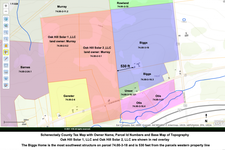
Show the building outlines and property lines and measure from neighboring houses to the solar project property line.
Turn on Ag districts – screen shot turn it off
Turn on Flood Zones, Turn on Topography, Turn on Parks
While capturing all of these screenshots try to keep the solar array centered on the screen. Don’t change scale. Keep everything the same.
Save every screen shot as a PDF.
File the screen shots and PDFs in separate Folders
County Map Images
Agricultural Districts
Distance to Neighbors
Flood Zones
Neighbors Tax Maps
Omitted Houses
Parks
Topography
Wetlands
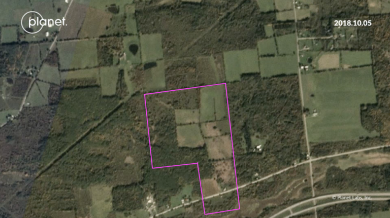
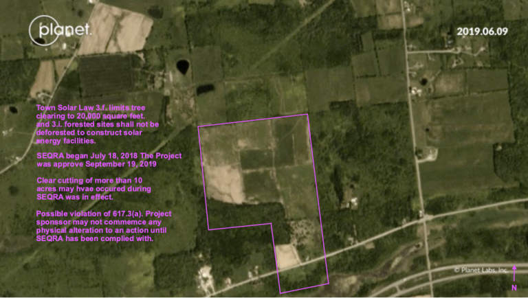
4. Use Google map, Bing Map, Acre Value Map, planet.com map and capture screen shot.
File the images in the PDF in the correct folders.
5. Spend time to annotate the PDFs with distances, owner names, amount of vegetation, screening, location of the neighboring houses and any other relevant data. These images will be used again and again and again. Take the time to make your notes accurate, legible, and useful.
Sample Images for educational purposes only
MAPS OF INTEREST
U.S. Web Soil Survey
https://websoilsurvey.sc.egov.usda.gov/App/HomePage.htm
Schenectady Satelite Image Mapping System
http://www.simsgis.org/
New York State Department of Environmental Conservation Resource Mapper
https://gisservices.dec.ny.gov/gis/erm/
Google Maps
https://www.google.com/maps
Planet.com
https://www.planet.com/
Google Earth
https://www.google.com/earth/versions/
Bing Maps
https://www.bing.com/maps